I have visited Rohtas & Rawat Fort on Sunday, 21st October, 2007, with almost 30 photographers from RWP/ISB, Jehlum, Gujranwala and Lahore.
I want to share pictures with you guys.
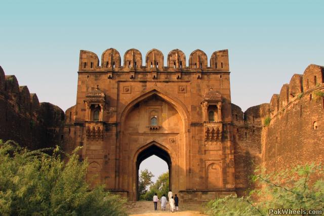
Rohtas Fort or (Qila Rohtas) is a garrison fort built by the great Afghan king Sher Shah Suri. This fort is about 4 km in circumference and the first example of the successful amalgamation of Pukhtun and Hindu architecture in the sub-continent.
Name of fort
Sher Shah Suri named Qila Rohtas after the famous Rohtasgarh Fort in Shahabad district near Baharkunda, Bihar which he captured from the Raja of Rohtas Hari Krishan Rai in 1539. Rohtasgarh is situated on the upper course of the river Son, 20 37’ N and 85 33’E. It was built by Harish Chandra of the Solar dynasty and was named after his son Rohitasva after whom the fort (Rohtasgarh) was named.
Reasons of construction
Sher Shah constructed Qila Rohtas to block Emperor Humayun's return to India after defeating him in the Battle of Kanauj. This fort lies on the old GT road between the North (Afghanistan) to the Plains of Punjab. It blocked the way from Peshawar to Lahore. The other reason was to suppress the local tribes of this region Potohar called Gakhars who were allies of Humayun and refused their allegiance to Sher Shah Suri. The Gakhars made a feeble retort by building some fortifications near the village of Sultanpur, which still remain today.
Location
Qila Rohtas is situated in a gorge approximately 16 km NW of Jhelum and 7 km from Dina. It was constructed on a hillock where the tiny Kahan river meets another rainy stream called Parnal Khas and turns east towards Tilla Jogian Range. The fort is about 300 feet above its surroundings. It is 2660 feet (818 meters) above sea level and covers an area of 12.63 acres.
Qila Rohtas is a garrison fort and could hold a force of up to 30,000 men. Due to its location, massive walls, trap gates and 3 Baolis (stepped wells) it could withstand a major siege although it was never besieged.
Most of the fort was built with ashlar stones collected from its surrounding villages such as Village Tarraki. Some part of the fort were built with bricks. The fort is irregular in shape and follows the contours of the hill it was constructed on. The fort is approximately 4 km in circumference. A 533 meter long wall divides the citadel (for the Chieftain) from other parts of the fort.
Listing in UNESCO's World Heritage List
In December 1997 Rohtas was listed in the UNESCO’s World Heritage List on the basis of criteria (ii) and (iv), considering that the Rohtas Fort is an exceptional example of the Muslim military architecture of central and south Asia, which blends architectural and artistic traditions from Turkey and the Indian sub-continent to create the model for Mughal architecture and its subsequent refinements and adaptations.
(Information by Muzzafar Bukhari)
You can also view my photography work on
http://www.flickr.com/photos/its_asif


